Critical Incident Mapping

Give responders a living digital map of your entire campus.

In a crisis, paper floor plans and out-of-date diagrams cost time you don't have. Critical Incident Mapping gives administrators and first responders an interactive, always-current map of rooms, doors, cameras, safety assets, and live alerts before they even arrive on site.

Request a Demo
Real-time campus map showing incident locations and safety assets
LIVE INTELLIGENCE

From Static Maps to Live Campus Intelligence

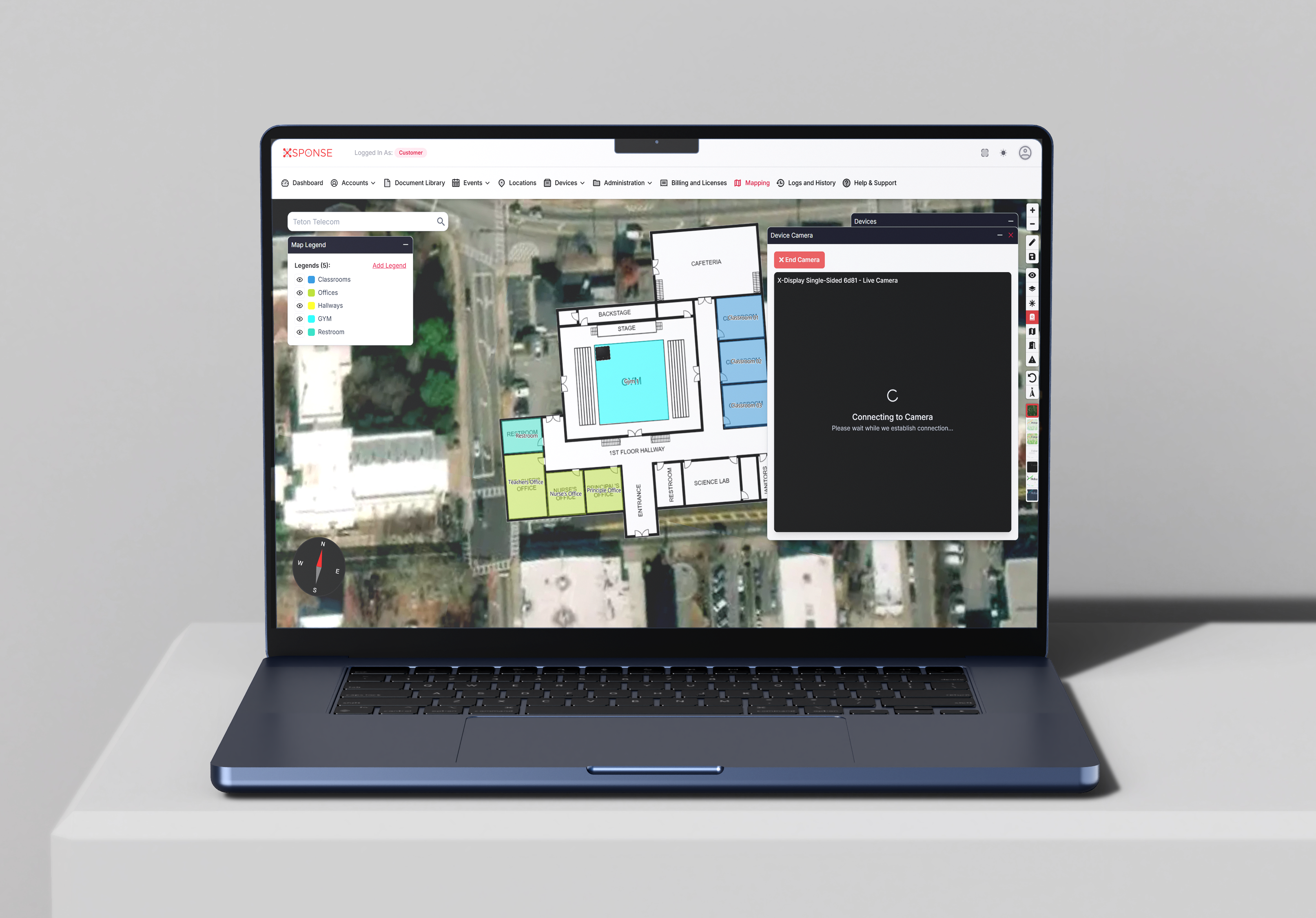
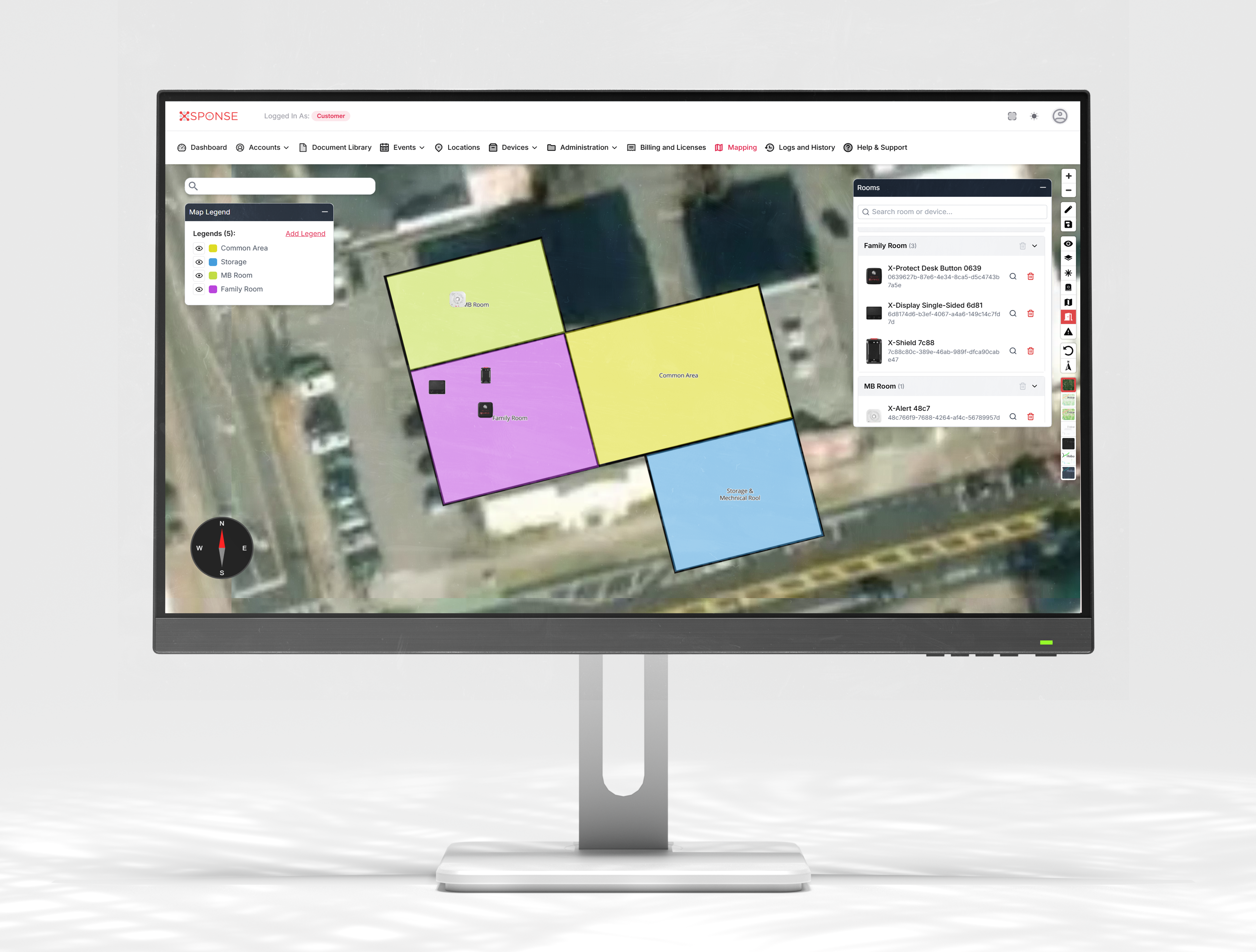
Traditional maps hang in binders or on walls and rarely match reality. Our digital mapping is tied directly into your XSponse ecosystem, so every alert and safety asset appears in context: where it is, what's nearby, and how to get there fastest.

When seconds count, responders don't hunt for information. They see exactly what they need, where they need it, in real-time.

Complete Safety Ecosystem Integration

Your campus map connects seamlessly with all your safety devices and systems through one unified platform.

XSponse platform showing integrated campus map with all safety devices and systems
WHAT THE MAP SHOWS

Everything Responders Need at a Glance

Your digital campus map isn't just a floor plan. It's a comprehensive intelligence layer that shows:

🏫

Every building, floor, classroom, and outdoor area. Complete campus topology with room-by-room detail.

❤️

Location of AEDs, fire pulls, extinguishers, bleed kits, and rally points. All safety assets mapped and accessible.

📹

Cameras, access points, and key infrastructure. See which cameras cover which areas instantly.

📍

Real-time locations of staff alerts, sensors, and visitors. Live incident data overlaid on your map when enabled.

COMPLIANCE & FUNDING

Built for Compliance & Funding Requirements

Digital critical incident maps are increasingly being written into state law and funding programs. Our mapping solution is structured to help districts align with these requirements and clearly demonstrate readiness to stakeholders and public safety partners.

State Law Compliance

Meet requirements for digital floor plans and emergency resource mapping.

💰

Grant Eligibility

Qualify for state and federal funding programs with documented mapping capabilities.

👮

First Responder Partnership

Share maps directly with 911 centers and local police for faster, more informed responses.

KEY CAPABILITIES

What You Get With Critical Incident Mapping

A complete digital mapping solution that transforms how you manage campus safety and emergency response.

🗺️

Digital Campus Floor Plans

Room-level detail with accurate dimensions, entry points, and facility layouts always kept current.

❤️

Emergency Resource Mapping

Location markers for AEDs, fire extinguishers, fire pulls, bleed kits, rally points, and more.

📡

Direct 911 Center Sharing

Share maps directly with dispatch centers and first responders before they arrive on scene.

Real-Time Updates

Live incident data overlays show alerts, staff locations, and active situations as they unfold.

🔧

Easy In-House Updates

Update maps yourself as buildings change with no waiting for outside vendors or expensive change orders.

Map-to-Video Integration

Platform showing map-to-video integration with live camera feeds

Click any location on your map to instantly view live camera feeds from that area.

Unified Safety Dashboard

Complete platform dashboard with maps and all integrated safety systems

Manage your entire campus safety ecosystem from one comprehensive dashboard.

Make Sure Responders Never Waste a Second Looking for the Right Door

See how Critical Incident Mapping gives your team and first responders the precise, real-time information they need to respond faster and more effectively.

Talk About Mapping Your Campus